Mojave Road er 150-mile (240 km) historisk sti, der løber øst-vest gennem Mojave National Preserve i Californien.
Vejen blev oprindeligt brugt af indianere, og senere af amerikanske bosættere og militært personel.
I dag, det er en naturskøn og udfordrende rute, der byder på en fantastisk udsigt over ørkenlandskabet.
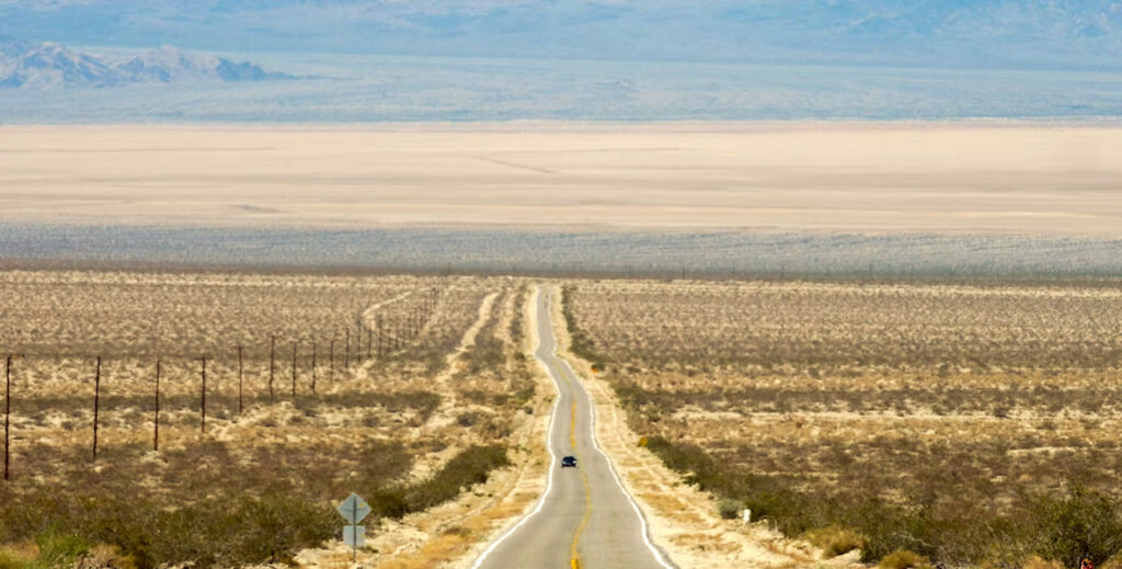
Kører Mojave Road
Mojave Road er nu en populær destination for offroad-entusiaster. Vejen er ikke asfalteret, og nogle sektioner er ru og sandede. 4×4 køretøjer anbefales, men 2WD-køretøjer med høj frihøjde kan også klare turen.
Mojave Road passerer gennem en række ørkenlandskaber, herunder klitter, bjerge, og dale.
Langs vejen, du vil se forladte miner, gamle forter, og indianske helleristninger.
Du kan også støde på dyreliv såsom prærieulve, storhornsfår, og ørkenskildpadder.
Det bedste tidspunkt at besøge Mojave Road er i løbet af foråret eller efteråret, når vejret er mildt. Vejen er lukket om vinteren på grund af sne og is.
Rute & Landemærker
Vejen begynder ved Colorado-floden nær Needles, Californien, og ender ved Mojave-floden nær Wilmington, Californien.
Langs vejen, den passerer gennem en række ørkenlandskaber, herunder klitter, bjerge, og vasker.
Mojave vejkortColoradofloden
I begyndelsen af dit Mojave Road eventyr, vil du finde dig selv stående nær Beale's Crossing på den vestlige side af Colorado-floden. Denne ikoniske vandvej tjente som et vigtigt krydsningspunkt for tidlige pionerer og opdagelsesrejsende, der rejste gennem regionen. Brug et øjeblik på at forestille sig spændingen og udfordringerne for dem, der begav sig ud på deres ørkenrejser fra dette historiske udgangspunkt.
Beaver Lake
Beliggende ca 2.5 til 3 miles nord for flodkrydsningen, Beaver Lake var engang en sø eller slough dannet af forårets oversvømmelser i Colorado-floden. I det 19. århundrede, det spillede en afgørende rolle for rejsende langs Mojave Road. Imidlertid, på grund af anlæg af opstrøms dæmninger, søen tørrede efterhånden ud, efterlader en ørken playa, som siden er blevet omdannet til landbrugsjord. Når du krydser stien, du vil passere gennem resterne af denne tidligere vandfunktion, giver et indblik i den dynamiske natur af Mojave-ørkenens landskab.
Piute Creek
Mens du rejser langs Mojave Road, du vil støde på Piute Creek, en lille ørkenoase hentet fra en naturlig kilde. Denne forfriskende vandkilde opretholder et levende økosystem, giver et tilflugtssted for planter og træer, der trives året rundt. Kontrasten mellem den frodige oase og de tørre ørkenomgivelser er virkelig bemærkelsesværdig. Brug et øjeblik på at værdsætte naturens modstandsdygtighed, mens du ser den blomstrende vegetation langs åen, give husly og næring til forskellige ørkenboende flora og fauna.
Fort Piute
Beliggende ved mundingen af Piute Creek, hvor oasen ender, Fort Piute blev bygget i 1867 af det amerikanske infanteri. This fort served as one of several guard posts along the Government Road, ensuring the safety of travelers between Fort Mohave and San Bernardino. As you pass by Fort Piute, take a moment to imagine the challenges faced by those who defended this remote outpost in the harsh desert environment.
Lanfair Valley
Lanfair Valley has been home to cattle ranches since the 1880s. This picturesque valley offers expansive views of rolling hills and is a testament to the enduring spirit of ranching in the Mojave Desert. As you traverse this scenic landscape, take a moment to appreciate the rich history and the ranching heritage that has shaped this region.
Indian Hill og Indian Well
About a mile north of the Mojave Road at mile 40, you’ll encounter Indian Hill, which marks the summit on the south end of the Lanfair Buttes. Nearby, du finder også Indian Well, en gammel brønd af diskutabel oprindelse beliggende nordvest for Indian Hill. Disse vartegn giver et indblik i den indianske historie og betydningen af vandkilder i dette tørre ørkenlandskab.
Joshua træskov
Mens du fortsætter din rejse gennem Lanfair Valley, du vil støde på en tæt Joshua Tree Forest. Disse unikke og ikoniske træer, med deres snoede grene og spidse blade, skabe et surrealistisk og fængslende landskab. Joshua Tree Forest langs Mojave Road er et vidnesbyrd om naturens modstandsdygtighed i det barske ørkenmiljø.
Rock Spring
Rock Spring er et betydeligt vandhul langs Mojave Road, tilbyder en forfriskende oase i ørkenen. Vandløbet løber ned ad store kampesten, skabe rolige og maleriske omgivelser. Denne placering har også en gammel hytte, tilføjer et strejf af historie til områdets naturlige skønhed. Brug et øjeblik på at slappe af og nyde den fredelige stemning i Rock Spring.
Regeringshuller
Beliggende i Round Valley, vest for Rock Spring, Government Holes er en anden vital vandforsyning langs Mojave Road. Dette område har et gammelt betontrug, der tjente som vandsted for rejsende og deres husdyr. Tilstedeværelsen af Government Holes er en påmindelse om de logistiske udfordringer, som dem, der krydsede ørkenen, stod over for, stole på disse vandkilder for at overleve.
Cedar Canyon
Forbered dig på en højdeændring, når du krydser Cedar Canyon, det højeste punkt langs Mojave Road. Når du stiger op gennem Mid Hills, du når en højde på 5,000 fødder (1,500 meter). The scenic beauty of this area is enhanced by the unique rock formations and panoramic views of the surrounding desert landscape. Take a moment to appreciate the breathtaking vistas before continuing your journey.
Kelso-Cima Road
At mile 62, you’ll encounter the Kelso-Cima Road, marking the middle point of your Mojave Road adventure. This is the last paved road you’ll see for a long stretch, emphasizing the remoteness and solitude of the Mojave Desert. As you leave the comfort of the pavement behind, brace yourself for a true off-road experience that will immerse you in the rugged beauty and untamed wilderness of the Mojave Road.
Mergel forår
Marl Spring is a natural spring located at mile 70 along the Mojave Road. This oasis in the desert provides a reliable water source for plants, dyr, and weary travelers. The spring is accompanied by a primitive concrete trough, serving as a reminder of the historical importance of water in sustaining life along the Mojave Road. Take a moment to appreciate the delicate balance of ecosystems and the significance of water in this arid environment.
Mojave Road postkasse
As you reach mile 74, you’ll come across the Mojave Road Mail Box. This solitary flagpole and mailbox serve as a unique landmark along the trail. Take a moment to sign your name in the guestbook or leave a message for future travelers. The mailbox symbolizes the shared experience of those who have ventured on this historic route, creating a sense of community and connection in the vastness of the desert.
Pilevask
Willow Wash is a wash characterized by its heavy sands, located south and west of the Cima Volcanic Range and Volcanic Fields. It parallels Kelbaker Road and eventually breaks up into distributary washes beyond Seventeen Mile Point. As you navigate this section of the trail, be mindful of the sandy terrain and enjoy the unique geological features that make this area a fascinating part of the Mojave Desert.
Kelbaker Road
At mile 77, you’ll come across Kelbaker Road. This section of the Mojave Road is paved and serves as a connection between Baker and Kelso Junction. It provides a brief respite from the off-road adventure, allowing you to catch your breath and prepare for the next leg of your journey. Take a moment to appreciate the contrast between the ruggedness of the Mojave Road and the smoothness of the pavement as you continue on your desert exploration.
Sytten Mile Point
Located at mile 97, Seventeen Mile Point marks the halfway point between Soda Spring and Marl Spring. This mountainous area is home to the Seventeen Mile Point mining camp, showcasing remnants of past mining activities. As you traverse this section of the Mojave Road, take in the rugged beauty of the landscape and imagine the challenges faced by those who once sought their fortunes in these hills.
Sodasøen
Prepare for a unique sight as you approach Soda Lake at mile 100. This large dry lake presents a vast expanse of salt flats and desert scenery. Exercise caution while driving in this area, particularly during winter when the lake may be covered in water. The ever-changing landscape of Soda Lake offers a stark reminder of the Mojave Desert’s dynamic nature and the powerful forces that shape it.
Soda Springs i Zzyzx
Just beyond Soda Lake, you’ll encounter Soda Springs, located at the edge of the lake. This small private building serves as a reminder of the historic Zzyzx Mineral Springs and Health Spa that once operated in this area. Take a moment to appreciate the natural spring and its surroundings, reflecting on the history and significance of this location along the Mojave Road.
Rejsende monument
At mile 100, you’ll encounter the Travelers Monument, also known as the Government Monument. This unique landmark invites travelers to participate in a tradition by carrying a rock across the dry lake and adding it to the growing pile. The monument serves as a symbol of unity and camaraderie among those who have journeyed along the Mojave Road, leaving their mark as a testament to their shared adventure.
Rasor OHV-område
Located at mile 103, the Rasor Off-Highway Vehicle (OHV) Area offers an open-use space for off-road enthusiasts. This area provides opportunities for thrilling off-road adventures, including riding ATVs, motorcycles, and dune buggies. Embrace the adrenaline rush as you navigate through the sandy terrain and enjoy the freedom and excitement that the Rasor OHV Area offers.
Klitter
Prepare for some sandy fun at the Sand Dunes, located around mile 106. These soft sand dunes provide an opportunity to indulge in some thrilling sandboarding, sandslædekørsel, or simply enjoying the unique desert landscape. Feel the soft grains of sand beneath your feet as you explore this picturesque area and immerse yourself in the beauty and tranquility of the Mojave Desert.
Afton Canyon
Prepare to be awe-struck by the stunning beauty of Afton Canyon, located around mile 116. This deep canyon features steep walls and offers a captivating blend of natural wonders and scenic vistas. Take your time to appreciate the riparian habitat restoration efforts in this area and soak in the mesmerizing views of the canyon’s unique geological formations. Afton Canyon is a true gem along the Mojave Road.
Mojave River Crossing
Located at mile 121, the Mojave River Crossing offers a unique water crossing experience on the Mojave Road. Traverse the Mojave River, the only water crossing on this trail, and witness the beauty of this natural waterway in the heart of the desert. Take a moment to appreciate the contrast between the arid desert surroundings and the life-sustaining presence of the Mojave River.
Manix vask
At mile 133, you’ll reach Manix Wash, marking the exit point of the Mojave Road. This wash is a notable geographical feature where the trail concludes. Take a moment to reflect on the journey you’ve embarked upon and appreciate the rugged beauty of the Mojave Desert as you bid farewell to the Mojave Road.
Camp Cady
Located at mile 136.1, Camp Cady is a former U.S. Army Camp situated along the old Mojave Road, adjacent to the Mojave River. This historic site dates back to the mid-19th century and played a significant role in the region’s military history. Take a moment to explore the remnants of this camp and imagine the lives of soldiers who once occupied this strategic outpost.
Fork of the Road
Located at mile 147, the Fork of the Road marks an important junction along the north bank of the Mojave River. This junction is where the old Mojave Road splits off from the route of the Old Spanish Trail/Mormon Road east of Yermo. Take a moment to appreciate the historical significance of this location as a point of divergence for travelers during the early days of western expansion.
Tromme Kaserne
As you near the end of the trail in the west, at Wilmington, Englene, you’ll come across Drum Barracks. This historic site, situated at 33.78466°N 118.258163°W, holds significance as the final landmark on the Mojave Road. Explore the remnants of this former U.S. Army post and reflect on the rich history and cultural heritage of the region as you conclude your Mojave Road journey.
Din nr. 1 kilde til information om verden af sandsport og ørkeneventyrrejser. Vores artikler er resultatet af omfattende forskning, personlig erfaring, og vidensdeling inden for det globale sandboarding-fællesskab.